Description
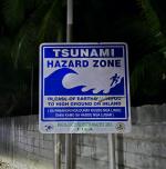
A tsunami hazard zone in the municipality of Lili along the Bohol Circumferential Road on the island of Bohol.
On February 8 1990 at 3:15 pm, a 6.8 magnitude earthquake struck Bohol island, causing significant damage and panic. The epicenter was 17 kilometers east of Tagbilaran City, with the strongest effects in Jagna, Duero, and Guindulman. The quake caused ground fissures, landslides, rockfalls, subsidence, and sea level rise, primarily in the northeastern part of the island.
The earthquake, likely involving the Alicia thrust fault, damaged around 3,000 structures, including two historical churches and 200,000 square meters of fishponds. Infrastructure damage included a collapsed bridge and cracked roads. Six people died, over 200 were injured, and 46,000 were displaced, with 7,000 left homeless. The total property damage was estimated at 154 million pesos.
The sign reads: "IN CASE OF EARTHQUAKE, GO TO HIGH GROUND OR INLAND"
Help us provide more detailed information about this project by
contributing!